Pirahã
- Self-denomination
- Hiaitsiihi
- Where they are How many
- AM 592 (Siasi/Sesai, 2014)
- Linguistic family
- Mura
The Pirahã call themselves hiaitsiihi, a category of human beings or bodies (ibiisi) that differentiates them from Whites and other Indians. They possess an elaborate naming system intimately connected with their cosmology. Even before birth, while still in the maternal womb, they receive their first name: this name is believed to be responsible for the creation of their bodies. During life, they receive further names from beings dwelling in higher and lower layers of the cosmos, responsible for the creation of their souls and destinies, as well as names from war enemies.
Name
The Pirahã are direct descendents of the Mura. Their language, material culture, social organization and physical similarity leave no doubt concerning their past links with this people. Nimuendajú (1982a/1925) was the first to make the association between the two groups, subsequently referring to the Pirahã as Mura-Pirahã. From this point on, the history of the two groups has been irrevocably bound together, making it usual to think of the Pirahã as the latter-day survivors of the ancient ‘Mura Nation,’ once inhabiting the margins of the Madeira river (cf. Nimuendajú, 1948, 1982a; Rodrigues & Oliveira, 1977; Oliveira, 1978).
Pirahã is the term by which regional populations classify them and how they identify themselves when dealing with this surrounding population and other indigenous groups. Hiaitsiihi is the group’s self-denomination, meaning one of the ibiisi (body) beings inhabiting one of the many layers that make up the cosmos.
Language
Apaitsiiso (‘that which comes out of the head’) is the term by which the Pirahã refer to their language. The Pirahã language was classified as a member of the Mura family by Nimuendajú (1982a). Henrichs (1964) classified it as tonal. Everett has analyzed the language in numerous works (cf. 1979, 1983, 1985a, 1985b, 1986a, 1986b). A tonal language is characterized by its manipulation of supra-segmental resources (the relation between tones) in order to establish meanings. Thus on the basis of tones, the Pirahã can generate specific modes of communication: by means of cries, whistles, and ‘eating-speech.’ Cries enable communication over a large distance and are generally used to converse while they are navigating in one or more canoes on the river. Communication by means of whistles occurs during expeditions in the forest or on rivers, when voiced speech could risk undermining the expedition’s objective. Everett (1983) documented that the whistles follow tones and not a standardized tonality that establishes a meaning. In this way, the Pirahã are capable of providing words and even phrases through the recourse to whistles. ‘Eating-speech’ is a third possibility for establishing communication by means of tones: they can continue talking while chewing on food.
Most men understand Portuguese, though not all of them are able to express themselves in the language. Women have little understanding of Portuguese and never use it as a form of expression. The men developed a contact ‘language’ allowing them to communicate with regional populations, mixing words from Pirahã, Portuguese and the Amazonian língua geral (a Tupi-based trade language more commonly known as nheengatu).
Location
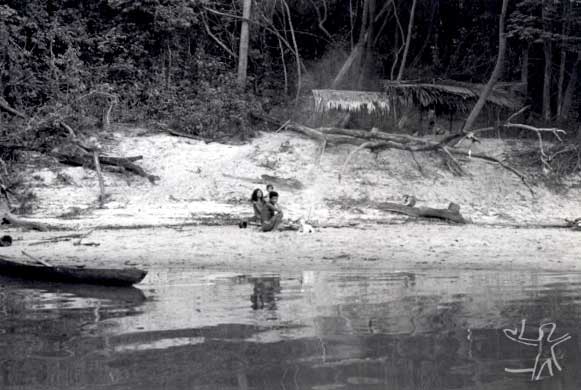
The Pirahã inhabit a tract of lands traversed by the Marmelos river and almost the entire length of the Maici river, located in the municipality of Humaitá in Amazonas state. The Maici river is one of the sources of the Marmelos river, an affluent of the left bank of the Madeira river. The dry and rainy seasons provoke important alterations in the region’s occupation. The Marmelos is a wide black water river, whose shores present dense forest growth and leafy trees, vegetation typical to tropical rainforest. In the dry season, white sandy beaches are exposed, interspersed by stretches of rocks and islands, along its entire length. In the rainy season, the waters invade the forest, forming extensive igapós (flooded areas of forest), which allow only the canopies of trees and ‘high lands’ to appear.
Journeying upriver on the Marmelos, a long straight tract can be seen, called ‘Large Stretch:’ this marks the start of Pirahã territory. Proceeding further in the same direction, close to the mouth of the Maici river, one of the main beaches on the Marmelos can be found, a strategic settlement site, since it provides access for exploration of both rivers. Crossing the mouth of the Maici, still on the Marmelos, numerous beaches, lakes, and creeks are passed, as well as the Juqui and Sepoti rivers. The latter marks the limits of Pirahã territory, since their topographic and toponymic references run out on its borders.
The Maici river is narrow and deep. Hundreds of Brazil-nut trees can be seen while travelling along its length. Occupation on this river extends from its mouth to the areas bordering its source: the bridge crossing it on the Transamazonian highway, 90 kilometers from the town of Humaitá, marks the limit of Pirahã territory. The Maici flows through an upland area, providing strategic points for exploiting its 17 Brazil-nut tree stands. Small beaches form during the summer which serve as temporary dwelling sites.
The Pirahã land was demarcated in 1994, its northern border being formed by the Marmelos river, from Folharal creek to Água Azul creek, following the left bank of the latter river along its full course; the southern limit comprises the bridge over the Maici river on the Transamazonian highway; the eastern and western borders are composed of an extensive tract moving inland more than 8 kilometers from the river’s left and right shores respectively. Overall, the region comprises approximately 400 thousand hectares within a perimeter of 410 kilometers.
Demography
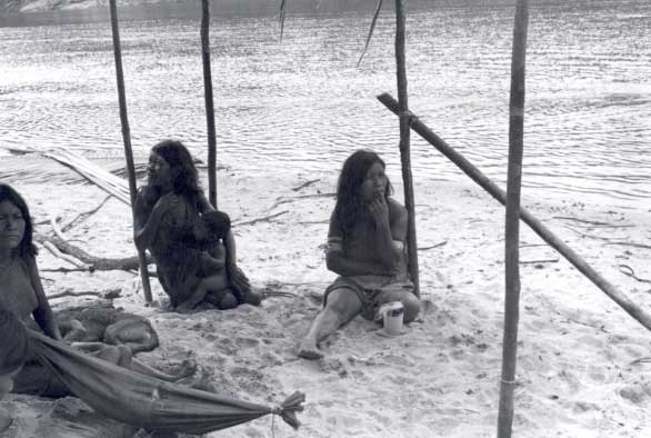
The current Pirahã population is approximately 360 people. During both the 1920s and the 1970s, the estimated number was 90. In 1985, the date of the first census, FUNAI ("Fundação Nacional do Índio - National Indian Foundation, governmental agency) counted 141 people, registering an equal distribution between the sexes (cf. Levinho, 1986). In the dry season, this population is spread out in small groups along the Maici and a long stretch of the Marmelos river, concentrating their activities on the harvesting of Brazil-nuts in the locations where the product is exploitable. Two large Pirahã populational groups divide the territory. A group of approximately 120 individuals inhabits the region formed by the Marmelos and the shores of the Maici, as far as a place named Cuatá. Another grouping, composed of 100 people, lives about two days boat journey away from this place (Cuatá), occupying at least four sites as far as the Transamazonian.
According to the Pirahã, until the 1960s, these groups lived together at sites close to the Maici’s mouth. The alleged motives behind the separation of the groups and the movement inland of a large number of people to the region of the upper Maici, were conflicts provoked by the ‘theft’ of women, leading to two murders. As a result, the crisis defined a new configuration in the territory’s occupation.
Contact history
The Pirahã, properly speaking, appear in chronicles and documents only from the end of the 19th century and the start of the 20th. in 1921, Nimuendajú encountered a Pirahã village on the Large Stretch of the Marmelos and another on the lower course of the Maici. He tells us that, in 1921, the SPI ("Serviço de Proteção aos Índios" - Indian Protection Service, the governmental agency preceding FUNAI) set up a post on the Maici in order to deal with these Indians who, in his opinion, are “happy in their poverty, ...until today they have paid little interest in the advantages of civilization and, except for tools, almost no signs of permanent contact with civilized people can be found among them. They are extremely indolent, but peaceful, so much so that I can record no hostility against civilized people, invaders of their Brazil-nut tree stands, despite the frequent abuses committed by these intruders.” (Nimuendajú, 1982a:117). Nimuendajú documented conflicts between the Pirahã, Matanawi and Parintintin in the region of the upper Maici. Also dating from this time is the information supplied by Gondin (1938), who attributes the Pirahã with the same bellicose attitude found among the Mura. According to this author, the Pirahã were at war in the upper Maici with the Torá and Parintinin, maintaining this state of open hostility until 1922, date of the installation of a surveillance post by the SPI (cf. Gondin, 1925).
1959 saw the arrival of the Summer Institute of Linguistics (SIL), which remained in the indigenous area until 1980. One couple worked there between 1960 and 1966, followed by another couple from 1967 until 1977. SIL based its Mission at three different localities: on the Large Stretch of the Marmelos, inland of the Maici river at a place called Tuxaua, and on a cliff named ‘New Post,’ close to the mouth of the Maici. Though the missionaries stayed in permanent contact with the Pirahã for more than 20 years, providing assistance and pursuing evangelical work, it is difficult today to identify any traces of their close contact with the group.
Information found in SIL’s reports reveals the difficulties it had in setting up a Mission, due to the fact the Indians were “scattered at various points along the rivers,” the women’s avoidance of dialogue with strangers, as well as the SIL’s conflicts with the regional population who did not want any kind of control over the territory.
In 1967, conflicts are reported between the Pirahã and Whites, provoked by commerce in Brazil nuts, resulting in the death of an Indian. In 1968, a measles epidemic killed 10% of the indigenous population, causing 14 mortalities. In 1971, more conflicts with regional workers took place during the Brazil-nut harvesting season, during which a Pirahã man is knifed and thrown in the river. After this episode, the Indians consider migrating to the headwaters of the Maici’s creeks, thus escaping further clashes with the Whites.
A report from 1979, written by a voluntary Catholic missionary who lived for 10 months with the Pirahã at the mouth of the Maici, estimated their population to be 107 individuals – 56 living on the lower Maici and 51 in the villages on its upper course. He also reported that in 1974 the group was hit by a measles epidemic, killing more than 30 people.
20th century information on the Pirahã – supplied by Nimuendajú, SIL missionaries, Funai workers and anthropologists – emphasizes that, although in close contact with Whites, the group succeeded in maintaining its cultural tradition and its own lifestyle. The region formed by the Marmelos and Maici rivers is still invaded today during certain periods of the year by commercial workers from Manicoré, Auxiliadora, Humaitá and Porto Velho. Since the start of the 20th century, these consulted sources describe the conflictual involvement of the Pirahã with the agents heading the Brazil-nut extraction. Movement of boats on the Maici is continual during the rainy season. Until 1985, the regional workers occupied production sites along this river, exploring the surrounding Brazil-nut tree stands.
Nowadays, the situation has changed considerably. After intervention from Funai and a team from CIMI ("Conselho Indigenista Missionário" – Missionary Indigenist Council), active in the area since 1991, the Pirahã were able to occupy the Brazil-nut tree areas in the Maici river area, collecting the product directly to trade for flour, ammunition, clothes and work tools with local merchants, in negotiations intermediated by the CIMI team.
Social organization
The Pirahã conceive time as an alternation between two well-defined seasons, marked by the quantity of water each one possesses: piaiisi (dry season) and piaisai (rainy season). These temporal demarcations combine with forms of socio-spatial organization. This presents us, therefore, with a series of oppositions conceived on the basis of relations between space and time:
|
Dry season
|
Rainy season
|
| beach | tupland |
| family house | collective house |
| concentration | dispersion |
| abundance | scarcity |
| ritual life | daily life |
Organization of social life on the basis of the two seasons is projected onto space, thereby creating a beach space-time versus an upland space-time.
The Pirahã organize themselves into small residential nuclei, whose number varies according to the season of the year. An average of 5 groupings is found during the dry season and 10 to 13 during the rainy season. These nuclei are concentrated in two distinct areas of the territory, the upper and lower Maici, thus conforming to larger sets that encompass the different residential patterns.
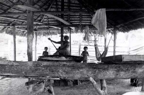
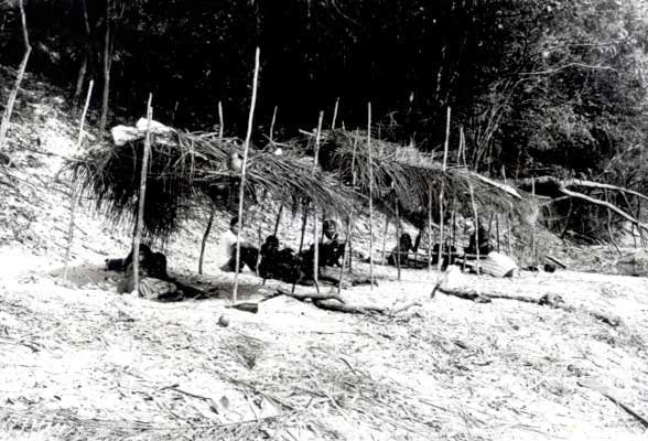
The nuclei making up part of a set maintain relationships governed by spatial contiguity and the bonds of consanguinity and affinity. The two wider sets are separated by a considerable distance and are practically independent, with only sporadic relations between their members. As a consequence, social relations, marriages, exchanges and communal rituals take place in the interior of each set.Within residential nuclei, it tends to be difficult to delineate the domestic group or elementary family as a unit of production and consumption. The couple is the most perceptible unit; by means of this unit, the fragmentation of social life gains cohesion and a form of systemization. Kage is the term used for a relationship between two people of opposite sex, not necessarily implying sexual relations and/or children. The couple’s autonomy is made evident in the fishing and gathering expeditions; the couple remains alone for days or weeks, thereby giving the idea that this is sufficient to constitute a social life. On one hand, the couple produces fragmentation, stimulating an autonomous, non-gregarious lifestyle, marked by a provisional mode of living (constant relocation, fragile shelters, few goods). On the other hand, the couple appears as a fundamental unit, operating as an regulator of sexual relations, weaving, however tortuously, the social fabric.
The set encompassing the residential nuclei of the lower Maici is the more populous. The conformation of these sets and their maintenance over time are due to three factors: ‘territorial inheritance,’ classification of kin as ‘close’ and ‘distant’ and the preference for marrying within a set.
Two distinct forms of classification are created through the notions of consanguinity and affinity: distant kin, the mage, and close kin, the ahaige. Based on these classifications, distinct forms of reciprocity are engendered and, as a consequence, differences that reproduce levels of inclusion and exclusion of the residential nuclei or larger sets.
Matrimonial arrangements are also responsible for the way in which people are organized in spatial terms. Marriages can occur within the same residential nucleus, between nuclei, or even take place between sets.
In Pirahã society it is rare to hear someone call or refer to another person in kinship terminology; kin terms do not serve as an emblem for interpersonal relations. The fact that they are not enunciated does not mean they do not fulfil a classificatory function or that they do not inform the way in which these interpersonal relations take shape. Four basic terms can be found employed in a primary classification of the universe of kin. These terms, prefixed or suffixed to other words, produce the derived modes for classifying a relationship. The three derived modes are defined by the fixation of elements (such as pronoun, verb and substantives defining sex and age) to the basic term.
The Pirahã kinship system can be included as an example of an ‘elementary structure,’ taking into account the fact that the term ibaisi corresponds to female bilateral cross cousins and is the way in which Pirahã men in practice refer to the women they marry. In the Pirahã case, the term ibaisi covers the genealogical positions of ‘female cross cousins’ (mother’s brother’s daughter and father’s sister’s daughter), and is in fact the only trace, at a terminological level, indicating virtual affinity in this context.
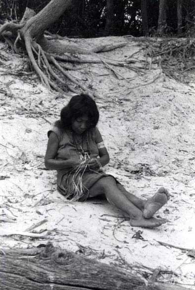
A man maintains direct relations with his mother, father’s wife, sister, female parallel cousin, female cross cousin, mother-in-law, sister-in-law, wife, daughter and wife’s daughter. Taking into account that men are responsible for fishing and swiddens, the principle productive activities in Pirahã society, they have to be the main providers of food. A man’s relations with his mother, sister and parallel and cross cousins are ahaige in kind, meaning that the man ‘must fish’ for these women. If he is married, this practice also applies to his wife, his daughters and his wife’s daughters. His mother-in-law and sister-in-law have access to the his catches of fish via his wife. A man would never claim that he fishes for his father-in-law or brother-in-law, though these will have access to his fishing catch via the women.
Swiddens are related to men, generally brothers who unite to share the work and together ‘eat from that swidden.’ A man has access to the swidden products of another man through a woman, whereby he is able to eat from the swidden of the husbands of his mother, sister, daughter and wife’s daughter.
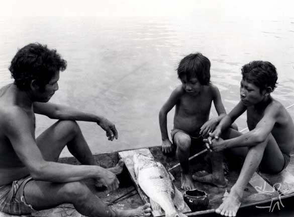
Hunting is a seldom practiced activity, though it may be undertaken by men and women. Men hunt with rifles (monkeys, tapirs, white-lipped and collared peccaries, agoutis, capybaras, pacas) while women hunt with the help of dogs (pacas, collared peccaries, agoutis). Gathering is a daily activity among the Pirahã, pursued in both the dry season and rainy season, by men and women.
Cosmology
The cosmos is represented in a stratigraphic way: layers of land placed one on top of the other, producing parallel planes which do not physically communicate, except through the beings that inhabit them. What identifies these layers as members of the same class is their morphological base. Each level presents its own morphology composed of water, earth, trees and animals, varying only in form, size and number.
Although all the levels are designated migi, ‘earth,’ the difference between them is marked by their contents and the place they occupy in the structuration of the cosmos.
The Pirahã admit they do not know the exact number of levels. Despite the uncertainty in relation to the layers of earth composing the cosmos, people reduce this complex structure to a single model, retaining details and impressions for only five levels, which appear to make up the minimum possible form for representing their cosmology.
____________________ abaisi e ibiisi
____________________ abaisi e ibiisi
____________________ ibiisi
____________________ abaisi, kaoaiboge, toipe, ibiisi
____________________ abaisi e ibiisi
The lines correspond to the cosmic levels. Each of these is inhabited by particular beings (see the names on the right). The middle level is inhabited exclusively by ibiisi beings, the others by both abaisi and ibiisi, except for the level immediately below the middle, which also shelters the kaoaiboge and the toipe. Ibiisi is a generic designation for ‘human being:’ the Pirahã, Whites and other Indians are all ibiisi. What defines an ibiisi is its possession of a body with a specific form. The abaisi have the same general form as the ibiisi (they are anthropomorphic), but this form is imperfectly realized: they are defective or deformed beings. The kaoaiboge and toipe are posthumous transformations of the ibiisi, inhabiting the level immediately beneath the middle.
The Pirahã have an elaborate naming system directly linked to their cosmology. A Pirahã child receives its first name even before birth while still in the maternal womb. The received name has a close relation to fetal conception – it is the name of the body (ibiisi).
Another source of names comes from the abaisi beings who inhabit the cosmos. While the names linked to conception, origin names, are responsible for the creation of its matter, its support, the ibiisi (body), the names linked to the abaisi beings are related to its ‘soul,’ ‘destiny’ names.
The dead have an important role in the naming process. While the abaisi compete to provide names to give to the ‘soul’ or the possibility of a posthumous destiny, the dead in general compete for the responsibility to appear in the shamanic ritual, representing the name of the abaisi and passing them, via the shaman, to the ibiisi. The Pirahã belief is that by possessing an abaisi name, the transformation into kaoaiboge and toipe will be assured, each of these thus determining a destiny. Each abaisi name possessed by an individual refers to the possibility of his or her transformation into two beings, called kaoaiboge and toipe.
Kaoaiboge is a peaceful being that feeds on fruit and fish, a victim of the cannibalistic toipe. Thus, if an individual has eight abaisi names he or she will certainly have his or her destiny assured through transformation into eight kaoaiboge and eight toipe.
The relationship with enemies is another source of names. According to the Pirahã, a class of people designated euebihiai used to exist in their society. This category included the warriors/killers whose main objective was the killing of enemies and game, providing the ritual food to be consumed. Enemies produced names, game no, but both were treated in the some form in the rituals performed for their ingestion. The killers carefully observed the enemy before killing him in order to name him. The killer then gave the enemy the abaisi name possessed by a deceased person.
We can see that the logic of this type of onomastic practice was based on the physical similarity of bodies: an enemy body and a dead Pirahã body. Equal bodies, equal names. This logic is still employed today for naming strangers. In killing the enemy, the euebihiai acquired his name. He kept it for himself or transmitted it to other Pirahã.
Ritual and Shamanism
We can classify as belonging to the ritual plane all those actions that place the ibiisi into relationship with the abaisi and with the kaoaiboge and toipe. There are two types of ritual: shamanism and festivals. Both have the intention of placing the social domain into relation with the supernatural domain, but shamanism is the society’s most important ritual, while festivals, qualified as ‘big’ and ‘small,’ are complementary rituals.
Shamanism materializes the interactive process between the ibiisi and the abaisi and/or between the ibiisi and the abaisi, kaoaiboge and toipe. It is through the shaman and his performance that the encounter gains dramaticity and durability. The shaman ‘swaps places’ with the abaisi or with the dead by visiting their respective levels while the latter come to the Pirahã level. The shaman’s performance allows the society to increase and recuperate its onomastic legacy. Shamanism is a possible means for supplying society ‘new’ names. Their insertion in the onomastic is achieved by presenting abaisi names to the ibiisi for these to use them later in naming. Thus, the shaman is the base of the ritual, the only being capable of representing the entire cosmology in each session.
The ‘Big Festival’ and the ‘Little Festival’ have the same reason for existing: placing the cosmos in operation. In Pirahã perception, both rituals are performed with the intention of provoking sounds, making a noise, sufficient for the demiurge Igagai, dwelling on the second celestial level, to hear them, becoming aware of their existence and of the exact place where they are found.
The Pirahã’s worry that they may not being located by Igagai can be interpreted as a fear of a repetition of what is contained in a mythic fragment narrating the destruction of the world. This destruction was due in the final instance to the fact Igagai was unaware where the Pirahã were. It was only through the crying of women, who were alone and without fire, that Igagai was then able to hear and locate them and start reconstruction of the world.
Both rituals are preferably performed during periods of full moon. The full moon is interpreted by the Pirahã as an oven where Igagai toasts his manioc flour. We can surmise that performance of the ritual during full moon works on the assumption that if they can locate Igagai under the full moon, he can also locate the Pirahã.
Sources of information
- EVERETT, Daniel Leonard. Aspectos da fonologia Pirahã. Campinas : Unicamp, 1980. 142 p. (Dissertação de Mestrado)
- --------. Dialogue and selection of data for grammar. In: DASCAL, M. (Org.). Dialoguer an interdiciplinary approach. Amsterdan : John Benjamins Pu, 1985.
- --------. A língua pirahã e a teoria da sintaxe : descrição, perspectivas e teoria. Campinas : Unicamp, 1991. 400 p. (Línguas Indígenas). Originalmente Tese de Doutorado, Unicamp, 1983.
- --------. Pirahã clitic doubling. Natural Languages and Linguistic Theory, s.l. : s.ed., n. 4, p. 4, 1986.
- GONÇALVES, Marco Antônio Teixeira. O mundo inacabado : ação e criação em uma cosmologia amazônica. Rio de Janeiro : UFRJ, 2001.
- --------. Um mundo inacabado : cosmologia e sociedade Pirahã. Rio de Janeiro : UFRJ-Museu Nacional, 1995. 337 p. (Tese de Doutorado)
- --------. Mura-Pirahã : castanha por cachaça. In: RICARDO, Carlos Alberto (Ed.). Povos Indígenas no Brasil : 1987/88/89/90. São Paulo : Cedi, 1991. p. 300-1. (Aconteceu Especial, 18)
- --------. Nomes e cosmos: onomástica entre os Mura-Pirahã. Rio de Janeiro : UFRJ/Museu Nacional, 1990. 37 p. (Comunicação, 20)
- --------. Nomes e cosmos : reflexões sobre a onomástica Mura-Pirahã. In: VIVEIROS DE CASTRO, Eduardo; CUNHA, Manuela Carneiro da (Orgs.). Amazônia : etnologia e história indígena. São Paulo : USP-NHII ; Fapesp, 1993. p. 339-64. (Estudos)
- --------. Nomes e cosmos : uma descrição da sociedade e da cosmologia Mura-Pirahã. Rio de Janeiro : UFRJ-Museu Nacional, 1988. 384 p. (Dissertação de Mestrado
- --------. Os nomes próprios nas sociedades indígenas das terras baixas da América do Sul. BIB, Rio de Janeiro : Anpocs/Relume Dumará, n. 33, 1992.
- --------. A produção da afinidade no sistema de parentesco pirahã. In: VIVEIROS DE CASTRO, Eduardo (Org.). Antropologia do parentesco : estudos ameríndios. Rio de Janeiro : UFRJ, 1995. p. 207-28. (Universidade)
- --------. O significado do nome : cosmologia e nominação entre os Pirahã. Rio de Janeiro : Sette Letras, 1993. 170 p.
- --------. O valor da afinidade : parentesco e casamento entre os Pirahã. Rev. de Antropologia, São Paulo : USP, v. 40, n. 1, p. 55-107, 1997.
- GONDIN, Joaquim. Etnografia indígena. Fortaleza : Ed. Fortaleza, 1938.
- --------. A pacificação dos Parintintins. Comissão Rondon, s.l. : Comissão Rondon, n.87, 1925.
- HENRICHS, Arlo L. Os fonemas do Mura-Pirahã. Boletim do MPEG, Série Antropologia, Belém : MPEG, n. 21, 1964.
- NIMUENDAJÚ, Curt. The Mura and Piraha. In: STEWARD, Julian H. (Ed.). Handbook of South American Indians. Washington : Smithsonian Institution, 1948.
- --------. Os índios Parintintin do rio madeira. In: --------. Textos indigenistas. São Paulo : Loyola, 1982. p.46-110.
- --------. As tribos do Alto Madeira. In: --------. Textos indigenistas. São Paulo : Loyola, 1982. p.111-22.
- OLIVEIRA, Adelia Engrácia de. Introdução. In: UNIVERSIDADE DO AMAZONAS. Autos da devassa contra os índios Mura do rio Madeira e nações ro rio Tocantins (1738-1739). Manaus : FUA ; Brasilia : INL, 1986. p. 1-6.
- --------. A terminologia de parentesco Mura-Pirahã. Boletim do MPEG: Série Antropologia, n. 66, 33 p., 1978.
- --------; RODRIGUES, Ivelise. Alguns aspectos da ergologia Mura-Pirahã. Boletim do MPEG: Série Antropologia, n. 65, 54 p., 1977.
- ROPPA, Saviano. Os Mura-Pirahã. Arq. Inst. Anatomia e Antropologia do Inst. de Antropologia Souza Marques, Rio de Janeiro : Instituto de Antropologia Souza Marques, n. 3, p. 411-33, 1978.
- SPATTI SÂNDALO, Maria Filomena. Aspectos da língua Pirahã e a noção de polifonia. Campinas : Unicamp, 1989. (Dissertação de Mestrado)
- Tse Ibiisi Abaaigio (Somos apenas corpos). Dir.: Marco Antônio Gonçalves; Daniel Keller. Vídeo Cor, VHS, 30 min., 1991.